From: Influences on Wetlands and Lakes in the
Adirondack Park of New York State:
A Catalog of Existing and New GIS Data Layers for the
400,000 Hectare Oswegatchie/Black River Watershed, 1997
| I.A. Background | OB2 Contents |
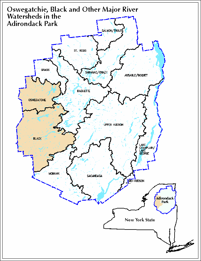
The Adirondack Park of New York State is experiencing the effects of acid deposition and watershed development on its lakes and wetlands. Within this 24 million hectare region, the Adirondack Park Agency is responsible for administrating laws that protect these resources with responsibilities ranging from resource planning and mapping to specific project review. The Agency is increasingly using a Geographic Information System (GIS) as a tool for regional assessments. This GIS characterization project is the second of a two-phase effort to examine watershed influences on the 400,000-hectare watershed of the Oswegatchie and Black Rivers (Figure IA.1). This project was accomplished cooperatively with the State University of New York at Plattsburgh and the Adirondack Lakes Survey Corporation. This project serves as a template for the rest of the Adirondack Park.
Phase I of the Oswegatchie/Black project, completed in 1996, created the databases for 1223 ponded watersheds and over 60,000 wetland hectares with more than 200 wetland types. This Phase II project provided new digital coverages and excerpted existing digital coverages for the same study area. New digital maps include: upland land cover (using LANDSAT Thematic Mapper imagery); recent major landscape disturbances (including 1950 blowdown, 1916 fire disturbance map, and State land acquisition map); and the July 1995 micro-burst storm map. Existing maps that were cartographically referenced from a number of sources include: Adirondack Park land use and development plan map; Adirondack Park 1989 residential areas map; bedrock and surficial geology; general soils map; elevation with shaded relief map; and recent atmospheric deposition (including total nitrogen deposition and mean annual precipitation).
A number of composite or interpretive maps were developed from these database layers to explore relationships with lake water quality and watershed attributes. These interpretive maps include: a recent landscape disturbance composite; a bedrock acid neutralizing capacity (ANC) map; and a soils parent material map. We present these coverages graphically and digitally as project products. We also examine some watershed characteristics in conjunction with lake ANC chemistry by focusing on 23 Adirondack Long Term Monitoring (ALTM) watersheds within the study area.
This Phase II study also provides a preliminary investigation of the atmospheric loading of acids and nutrients (namely nitrogen) to wetland (targeting peatlands) sensitivity. Also peatland identification is discussed as an integral and ongoing aspect of wetland watershed dynamics in the Adirondack Park. Finally, we also expected to learn from this project just how user-friendly this GIS system would be with a multi-disciplinary staff having varying experiences using computerized mapping and analysis.
| I.B. Objectives | OB2 Contents |
The following primary objectives were originally proposed for this study:
During the course of the study, additional goals were accomplished. For instance, a major windstorm event swept through the study area on July 15, 1995, that compelled us to incorporate into the project an examination of this major forest blowdown. A satellite image analysis was done by the Department of Geology at St. Lawrence University in cooperation with this project and the NYS Department of Environmental Conservation. Additionally, digital atmospheric deposition data became available from the Institute for the Study of Earth, Oceans and Space at the University of New Hampshire. The Adirondack Park Agency's Land Use and Development Map also became digitally available during the course of the project.
In the end, this project became the first major catalog of existing and new GIS data layers for a major (400,000-hectare) region of the Adirondack Park. During the course of the study, advances in technology allowed the compilation to be cost effectively produced on a compact disk, making widespread distribution of the data possible.
| I.C. Relationship to Other Studies | OB2 Contents |
The following is a list of ongoing or recently completed studies involving sampling of Adirondack waters. All of these projects have been funded partially or entirely by the U.S.Environmental Protection Agency.
| D. Organization of Report | OB2 Contents |
Section II. Map Development describes all the map coverages in this GIS catalog. Each subsection provides a general description of the data source. The metadata are provided on Compact Disk and will be available as part of this project. The wetland covertypes and lake watershed boundaries produced from the Phase I project are incorporated in this catalog. A summary table of data types, sources and scales for each of the data layers in the catalog, is provided at the end of Section II.
Section III. Peatlands as Critical Wetlands discusses the question of peatland distinction from other wetlands and of peatland sensitivity to additions of nutrients and acidity based on a review of the literature.
Section IV. GIS discussion assesses: the distribution of lake sensitivities to atmospheric deposition; predicting lake ANC from bedrock geology ANC contributions, with and without consideration to shallow soils; the distribution of low phosphorus lakes across the study area as related to watershed and shoreline development. Major landscape disturbances of lake watersheds is examined along with watershed attributes of the 23 Adirondack Long-Term Monitoring waters found in the study area.
Section V. Data information describes how to acquire data.
Poster/ report insert. The poster graphic provided at the back of this report illustrates the coverages in this digital catalog.
Continue reading next section of OB2 Report -- Map Development