Section II --
Map Development (continued) |
Local Table of
Contents:
|
From: Influences on
Wetlands and Lakes in the Adirondack Park of New York State:
A Catalog of Existing and New GIS Data Layers for the
400,000 Hectare Oswegatchie/Black River Watershed, 1997 |
 One of the
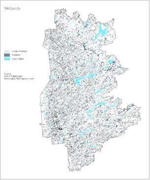
objectives of this project was to integrate the digital wetlands covertype data produced
in Phase I of the Oswegatchie/Black River Watershed Project into this catalog of
coverages. The final report of the Phase I project details the methods and provides
references and metadata for this coverage. The report is entitled Watershed
Protection for Adirondack Wetlands: A Demonstration-Level GIS Characterization of
Subcatchments of the Oswegatchie/Black River Watershed EPA Grant No. X-002777-01 Final
Report by K.M.Roy, R.P.Curran, J.W.Barge, D.M.Spada, D.J.Bogucki, E.B.Allen, and
W.A.Kretser 1996.
Another objective of this project was to continue the discussion of potential threats
to wetlands, particularly peatlands, in the Adirondacks. This discussion is provided in
Section IV of this report.
 One of the
objectives of this study was to examine the question of potential wetland sensitivity to
additions of nutrients and acidification. One aspect was to investigate the availability
of digital atmospheric deposition data for the study area that was temporally compatible
with the other data coverages. A further discussion of this objective can be found in
Section III of this report.
Description of existing data
The work of Ollinger et al. (1993) was available. It provides digital spatial
coverages of recent precipitation and total deposition of nitrogen and sulfur for the
Northeast region in GIS.
Available were:
ELEVATION. A digital elevation model (DEM) from U.S. Geological Survey (1987) covering
eastern New York with a geographic resolution of 30 arc-seconds.
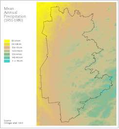
PRECIPITATION. Developed from long-term (30 yr) mean annual precipitation from National
Oceanic and Atmospheric Administration (1951-1980).
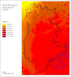
TOTAL NITROGEN AND TOTAL SULFUR. Deposition from the 1991 National Atmospheric
Deposition Program/ National Trends Network from 26 precipitation chemistry and 13 air
concentration monitoring stations across the Northeast region that had 3-11 years of data.
 Provided with
this report are precipitation, total nitrogen and total sulfur as raw data covering the
Oswegatchie/Black study area. Refer to Ollinger et al. (1993) for detailed methods.
Discussion
We used these data to display patterns and ranges across the Oswegatchie/Black River
study area. The following ranges are reported:
Mean Annual Precipitation (1951-1980): from 83 cm to greater than 148 cm.
Total Nitrogen, Annual (1991): from less than or equal to 6.66 to greater than 10.75
kg/ha.
Total Sulfur, Annual (1991): from 10.87 to 16.37 kg/ha.
At least one researcher has used these deposition data in combination with the wetlands
coverage to look at possible study sites for a peatlands nitrogen study (A. Aldous,
personal communication).
References
- Aldous, A. personal communication 1997, Cornell University, Ithaca, N.Y.
- Ollinger, S.V., Aber, J.D., Lovett, G.M., Milham, S.E., Lathrop, R.G., and Ellis, J.M.
1993. A spatial model of atmospheric deposition for the northeastern U.S. Ecol.
Applications 3(3):459-472.
 Digital
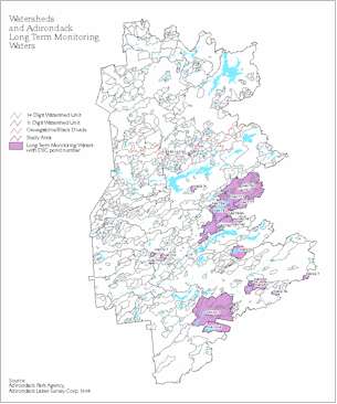
coverages for lake watershed boundaries were incorporated from the Oswegatchie/Black Phase
I project. These were used to link files with the Adirondack Lakes Survey Corporation data
and the Adirondack Long-Term Monitoring waters located in the study area.
Description of Existing Data
The lake watershed boundaries digital data contained a total of 1223 ponded waters
labelled with NYS Department of Environmental Conservation pond identification numbers
(Roy et al. 1996).
Adirondack Lakes Survey Corporation (ALSC)
The Adirondack Lake Survey Corporation was initiated in 1983 by the New York State
Department of Environmental Conservation and the Empire State Electric Energy Research
Corporation (ESEERCO) to quantify the chemistry and fisheries status of Adirondack waters.
This one-season summer sampling survey provided data for over 1469 lakes in the
Adirondacks between 1984-87. This effort resulted in the acquisition of extensive
physical, chemical and biological data. A statistical summary (Kretser et al. 1989)
and an interpretive report (Baker et al. 1990) were produced.
The Adirondack Long-Term Monitoring waters (ALTM)
The Adirondack Long-Term Monitoring (ALTM) program was started in 1982 on 17 lakes to
evaluate water chemistry changes during the year with the collection of monthly samples.
The ALTM program was expanded to be more representative of all categories of Adirondack
waters by the addition of 35 waters in 1992. This ongoing program is conducted by the
Adirondack Lakes Survey Corporation in cooperation with Syracuse University Department of
Civil and Environmental Engineering with support from the USEPA (Adirondack Lakes Survey
Corporation and Syracuse University 1997).
The Oswegatchie/Black study area contains 545 ALSC waters and 23 ALTM waters. The ALTM
waters are listed and their watershed characteristics described further in Section IV of this report (Table IV
A.4).
References
- Adirondack Lakes Survey Corporation and Syracuse University Dept. of Civil and
Environmental Engineering. 1997. Proposal for extension of: A long-term monitoring program
for evaluating changes in water quality in selected Adirondack waters. Submitted to
ESEERCO, NYSDEC and USEPA, Adirondack Lakes Survey Corporation, Ray Brook, NY.
- Baker, J.P., Gherini, S.A., Christensen, S.W., Driscoll, C.T., Gallagher, J., Munson,
R.K., Newton, R.M., Reckhow, K.H., and Schofield, C.L. 1990. Adirondack lakes survey: An
interpretive analysis of fish communities and water chemistry, 1984-87. Adirondack Lakes
Survey Corporation, Ray Brook, NY.
- Kretser, W., Gallager, J., and Nicolette, J. 1989. Adirondack Lakes Survey, 1984-1987.
An evaluation of fish communities and water chemistry. Adirondack Lakes Survey
Corporation, Ray Brook, NY.
- Roy, K.M., Curran, R.P., Barge, J.W., Spada, D.M., Bogucki, D.J., Allen, E.B, and
Kretser, W.A. 1996. Watershed protection for Adirondack wetlands: A demonstration-level
GIS characterization of subcatchments of the Oswegatchie/Black river watershed final
report. U.S. Environmental Protection Agency State Wetlands Protection Program Grant No.
X-002777-01.
 One of the
objectives of this project was to integrate the digital wetlands covertype data produced
in Phase I of the Oswegatchie/Black River Watershed Project into this catalog of
coverages. The final report of the Phase I project details the methods and provides
references and metadata for this coverage. The report is entitled Watershed
Protection for Adirondack Wetlands: A Demonstration-Level GIS Characterization of
Subcatchments of the Oswegatchie/Black River Watershed EPA Grant No. X-002777-01 Final
Report by K.M.Roy, R.P.Curran, J.W.Barge, D.M.Spada, D.J.Bogucki, E.B.Allen, and
W.A.Kretser 1996.

