 Description of
existing digital soils
Description of
existing digital soils| Section II -- Map Development (continued) |
Local Table of Contents: |
| From: Influences on
Wetlands and Lakes in the Adirondack Park of New York State: A Catalog of Existing and New GIS Data Layers for the 400,000 Hectare Oswegatchie/Black River Watershed, 1997 |
| II.I. General Soils-Parent Material Composite Map | OB2 Contents |
One of the objectives of this study was to determine the underlying soils for the study area by incorporating the best available digital data.
 Description of
existing digital soils
Source Data: Adirondack Park Agency (APA).
This coverage was produced in 1975 by the Adirondack Park Agency from County general soils maps which were prepared for the APA by the U.S.D.A. Soil Conservation Service as part of their assistance to county soil and water conservation districts in cooperation with Cornell University Agricultural Station. The base map was developed at 1:62500 by the State of New York Office of Planning Coordination. This map is referred to in this report as the "meso soils map".
Discussion
Parkwide, 132 map units or soil associations have been identified. Within the 400,000-ha Oswegatchie/Black watershed, 50 soil associations have been identified excluding water and mine dump categories (Table II.I.1). Five of the associations may be considered anomalies based on their small size. The resolution or accuracy of these units or distinction is 40-100 acres (16-40 ha). It is noted that there are some differences associated with matches across county boundaries.
Parkwide, soils have been categorized into nine soil parent materials. All of them are considered acidic, except glacial tills which are near neutral pH. In the Oswegatchie/Black River watershed, only one association, Madalin(f)NL, is so classified, and it is so small as to be considered an anomaly. Therefore, since all the other parent materials found in the Oswegatchie/Black watershed representing over 99.99% of the study areas are acidic, the parent material composite does not provide any differentiating specific information on soil chemistry. The most meaning can be derived by the physical properties of the parent materials, specifically in the way that water can move through them. We note that while carbonate rock inclusions are found in the study area, they are not fully explored or are not detected at this scale.
Table II.I.1 Meso soil associations for the
Oswegatchie/Black watershed area.
|
The nine parent materials found parkwide are listed below with Oswegatchie/Black (OB) annotations as to what each of them represent in the Oswegatchie/Black watershed:
- Organic
- Alluvial NONE FOUND IN OB
- Lacustrine ONLY ANOMALIES FOUND IN OB (#30, 40,54,78,126 which each represent less than 400 acres (162 ha) using 600 acres(243 ha) as the threshold. Together they represent less than 1000 acres (405 ha).
- Glacial outwash
- Glacial tills with near neutral pH ONLY ANOMALIES FOUND IN THE OB
- Ablation tills
- Basal tills
- Shallow soil over bedrock
- Beach deposit NONE FOUND IN OB
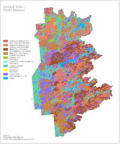
For this study, it was determined that the most meaningful groupings for soils would be by parent material with other considerations as described:
- SHALLOW TO BEDROCK SOIL - Rock outcrop dominate
- SHALLOW TO BEDROCK SOIL - Shallow soils dominate
- BASAL TILLS - Not hydric, Becket/Marlow soil catena
- BASAL TILLS - Not hydric, Potsdam soil catena
- ABLATION TILLS - Not hydric
- GLACIAL TILLS - Not hydric, near neutral pH (Anomalies only)
- GLACIAL OUTWASH - Not hydric (high potential for groundwater exchange)
- LACUSTRINE - Not hydric (Anomalies only)
- HYDRIC SOILS - Soils depth less than 6 in, described as poorly or very poorly drained.
These groupings became the legend for the general soils - parent material map interpretation (see poster graphic attached to this report). Soil depths are interpreted as: deep soils are greater than 60 inches; moderately deep soils are from 20 to 40 inches; and shallow soils are less than 20 inches.
References
| II.J. Elevation With Shaded Relief Map | OB2 Contents |
One of the objectives of this study was to provide existing pertinent coverages for the study area.
Source Data: U.S. Geological Survey Digital Elevation 1:250000 and Adirondack Park Agency
This coverage was produced by the Adirondack Park Agency from USGS digital elevation developed from cartographic and photographic sources (U.S. Geological Survey 1990) and shaded relief using standard ArcInfo techniques.
References
| Continue reading next section of OB2 Report -- Section II.K. | OB2 Contents |