GIS Archive
The Adirondack Park Agency (APA) uses GIS to understand and support the natural and cultural resources of the park in regional planning and jurisdictional review.
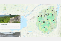
| 2023 State Land Classification Story Map | |
|
The 2023 State Land Classification Story Map provides a map tour with photos and descriptive text, to highlight the lands in the classification and reclassification of 5,818 acres of State Lands in the Adirondack Park. |
 |
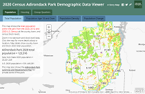
| Park Population from the 2020 Census | |
Adirondack Park 2020 Census Viewer - including population and housing data at the park, county, town, and census block levels. |
 |
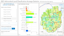
| Land Classification Acreage Statistics Update | |
2021 Adirondack Park state and private land classification acreage statistics for the park, counties, towns, and villages. |
 |
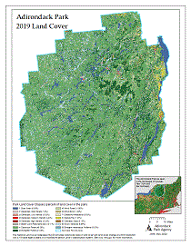
| Land Cover 2019 | |
2019 Adirondack Park land cover from USGS National Land Cover Data. |
 |
| Adirondack Park Land Use and Development Plan Map and State Land Map | |
Facsimile of the official 2023 50th anniversary zoning map showing private and state land classifications. Also includes the Adirondack portion of the NYS Wild, Scenic and Recreational Rivers System. View an interactive map. View a fullsize PDF map - March 2023 (26 MB) REST endpoints: Feature Service | Tile Service Download 2023 Shapefile suitable for use with GIS software. (42 MB apaLandClass202306.zip) |
 |
| Telecommunication Towers | |
Adirondack Park Cellular Towers Map New and existing structures for which the APA has permitted cellular service use (1993 - April 10, 2021). View map updated April 10, 2021. See Adirondack Park Towers Information for a complete list of permitted structures and other important information. |
 |
Adirondack Park Telecommunication Permitting Map New and existing structures for which the APA has permitted (1993 - April 10, 2021). View map updated April 10, 2021. See Adirondack Park Towers Information for a complete list of permitted structures and other important information. |
.jpg "click to view larger image") |
| Adirondack Park State Land Master Plan Map - June 1972 edition | |
June 1972 edition of the Adirondack Park State Land Master Plan map produced by the State of New York Adirondack Park Agency, Nelson A. Rockefeller, Governor. Indicates Wilderness, Canoe Area, Primitive Area, Wild Forest, Intensive Use state land classifications at that time. |
 |
| Park Visitor Interpretive Center Map - 2003 | |
"The Adirondack Park - A Map of State Forest Lands, Mountains, and Waters" Adirondack Park Visitor Interpretive Center (VIC) tourism map from 2003. Includes an Adirondack Gazetteer showing locations of state land units, populated places, major lakes, major mountains, and state campgrounds. The Adirondack Park Agency no longer operates the Paul Smiths VIC or the Newcomb VIC. |
 |
| Park Population Estimate of Towns from 2000 and 2010 Census | |
Census Population of Towns Within the Adirondack Park With Estimates for Census Blocks Straddling the Park Boundary. View 2010 Map | View slideshow (pdf 2.4MB) View 2000 Map | View slideshow (pdf 408kb) Additional estimates of seasonal population and several 2010 Adirondack region KMZ data layers are also available. |
 |
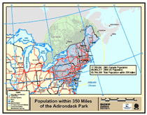
| Population within a Days Drive | |
The question was raised,"how
many people live within a days drive of the Adirondack Park?" This map and the GIS analysis behind it uses census data from the
US and Canada clipped with a 350 mile buffer around the Adirondack
Park. Our guess of a days car drive was derived from a 7 hour travel
day with an average speed of 50 miles per hour. view map (pdf 640kb) |
 |
| Easements | |
State owned Conservation Easements in the Adirondack Park from 2015 county parcel data. Parcels were identified using NYS DEC easement data. |
 |
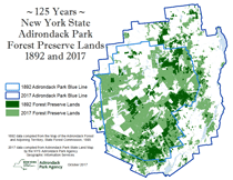
| Historic Forest Preserve | |
125 Years - New York State Adirondack
Park Forest Preserve Lands - 1892 and 2017 |
 |
| Schools | |
Adirondack Park School Districts
map |
 |
| Viewshed Protection | |
Town of Day Viewshed
Protection Area |
 |
| Zip Codes | |
Adirondack Park Zip Code Areas map |
 |
| Historic Snowmobile Use on Forest Preserve | |
The State Land Master Plan (SLMP) outlines a "mileage cap" of snowmobile trails at the time of its adoption in 1972. However, the exact location of those trails was not included. This begs the questions ?Where were those trails?? This map is a re-creation of the DEC 1972 snowmobile trail brochure entitled: Snowmobile Trails in New York State (10/1972) |
 |
| Military Training Routes | |
A map of New York's Air National Guard Adirondack Military Training Routes, or MTRs. |
 |
| Water Wholly Surrounded by Forest Preserve | |
A map of lakes and ponds wholly surrounded by Forest Preserve. |
 |
| Remsen-Lake Placid Travel Corridor Recreation Opportunities | |
A map of trails and roads aljacent to the Remsen-Lake Placid Travel Cooridor. A map of existing recreation opportunities and Natural Resources Limitations along northern portion of the Remsen-Lake Placid Travel Cooridor. view maps (pdf 3.84 Mb) UPDATED 2/28/14 |
 |
| Blueline | ||
| The Adirondack Park boundary. This boundary file should not be used for legal jurisdictional determinations. additional information | view online map | shapefile REST Feature Service |
| Adirondack Park Land Use and Development Plan Map and State Land Map | ||
| February, 2021 Private and State Land Classifcation GIS data. metadata | view online map | shapefile (42MB) REST tile service REST feature service |
| Designated Rivers System | ||
| Adirondack portion of the New York State Wild, Scenic, and Recreational, Rivers System. metadata | view online map | shapefile zip (1MB) REST feature service |
| Freshwater Wetlands | ||
The following two layers of wetland data are provided to assist the public in planning projects in the Adirondack Park. The data may not show all wetlands that are present in an area or the precise boundaries of wetlands. For a determination on whether a wetlands permit is required, project planners are encouraged to contact Agency staff. It may even be necessary for Agency staff to visit the property in order to assess whether wetlands will be affected by a planned project and to determine if a permit is needed. For more information, consult our Freshwater Wetlands page. |
||
| Official NYS Freshwater Wetlands - Regulatory wetlands in the Adirondack Park portions of Clinton, Essex, Lewis, Oneida, and Warren Counties promulgated pursuant to Article 24 of the Environmental Conservation Law (the Freshwater Wetlands Act.) | view online map | download data AGOL page REST tile service |
| Wetland Covertypes - Adirondack Park freshwater wetlands mapped by the Adirondack Park Agency with EPA funding. Wetlands are mapped by major watershed in the park. metadata | view online map | download data REST tile service |
| 2010 Census Data Adirondack Park Region | ||
| Adirondack Park Agency processing of 2010 US Census data for portion of northern New York State. | ||
| Places | places2010census.kmz | |
| Towns & Cities | county_sub2010census.kmz | |
| School Districts | school_districts.kmz | |
| Census Tracts | tracts2010census.kmz | |
| Census Blocks for the Adirondack Park (13Mb Esri File Geodatabase format GIS data) | Zipfile of File Geodatabase | |
| 2018 Park Land Use Classification Acreage Statistics | |
| State and private land class acreage and percent by county. | 2018 statistics |
| 2017 Park Land Use Classification Acreage Statistics | |
| State and private land class acreage and percent by county. | 2017 statistics |
| State and private land class acreage by county, town, and village. | 2017 statistics |
| 2014 Park Land Use Classification Acreage Statistics | |
| State and private land class acreage and percent by county. | 2014 statistics |
| 2011 Park Land Use Classification Acreage Statistics | |
| State and private land class acreage and percent by county. | 2011 statistics |
| 2009 Park Land Use Classification Acreage Statistics | |
| State and private land class acreage and percent by county. | 2009 statistics |
| 2007 Park Land Use Classification Acreage Statistics | |
| State and private land class acreage and percent by county. | 2007 statistics |
| 2003 Park Land Use Classification Acreage Statistics | |
| State and private land class acreage and percent by county. | 2003 statistics |
| 2000 Park Land Use Classification Acreage Statistics | |
| State and private land class acreage and percent by county. | 2000 statistics |
| Population - Seasonal Estimate | |
| An estimate based on parcels classified as seasonal residence in 2006 combined with US Census number of persons per household in 2000. | view statistics (pdf 23kb) |
| Park Population Estimate of Counties from 2010 Census | |
| Estimate of the Adirondack Park 2010 Population | view slideshow (pdf 2.4MB) |
| Park Population Estimate of Counties from 2000 Census | |
| Estimate of the Adirondack Park 2000 Population | view slideshow (pdf 408kb) |
| Mapping Historic Photos | |
| Historic Photo Geographic Inventory - A Guide for Geocoding Library of Congress Photo Images developed by the Adirondack Park Agency. | view paper (pdf 83kb) |
| Tip - Converting a GIS shapefile into a GPS Track | |
| One option for uploading a GIS shape layer into a GPS unit as a track for reference in the field. Not intended to endorse any particular vendors. | view slideshow (pdf 1.1MB) |
| Viewshed Protection Area Analysis | |
| Town of Day Viewshed Protection Area Analysis Presentation given to the 2007 NYS GIS Conference. | view slideshow (pdf 1.4MB) |
| Wetland Covertype Mapping | |
| EPA funded APA Wetland and Watershed Reports | index to reports |
| Mapping Wetlands with Aerial Imagery using Stereo Analyst for ArcGIS | |
| Slideshow of remote wetland mapping using 3D visualization technology. | view slideshow (pdf 4.6MB) |